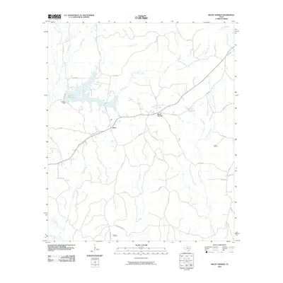
2010 Map of Mount Herman
USGS Topo · Published 2010About this map
The community of Mount Herman and the nearby settlement of Aiken anchor this East Texas landscape, which is defined by an intricate network of creeks and several significant water bodies. To the northwest, Pinkston Reservoir was created by the construction of Pinkston Dam along Sandy Creek, while the southern reaches of the quadrangle are bounded by the Attoyac River. The terrain is deeply carved by numerous drainages, including Little Iron Ore Creek, Bog Creek, and Dean Creek, which suggest the timbered and water-rich environment of the Piney Woods region.
Find a feature on this map
45 named features on this map. Tap any name to fly to it.
Don’t see what you’re looking for? This feature index may not catch every label — zoom into the map to look around manually.
Map Details
Editions of this 2010 Mount Herman Map
This is the sole edition of this map. No revisions or reprints were ever made.
Other maps of this area

1953 · Palestine
USGS Topo · 1:250,000

1957 · Palestine
USGS Topo · 1:250,000

1958 · Center
USGS Topo · 1:62,500

1958 · San Augustine
USGS Topo · 1:62,500

1958 · Martinsville
USGS Topo · 1:62,500

1958 · Timpson
USGS Topo · 1:62,500

1984 · Palestine
USGS Topo · 1:250,000
1984 · Center
USGS Topo · 1:24,000
1984 · Chireno North
USGS Topo · 1:24,000
1984 · Garrison East
USGS Topo · 1:24,000