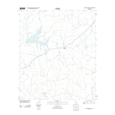
2013 Map of Mount Herman
USGS Topo · Published 2013About this map
Pinkston Reservoir and the Soil Conservation Service Site 15 Reservoir anchor the water management landscape of this Shelby County region. The terrain is defined by a dense network of drainage systems, including Sandy Creek, Little Iron Ore Creek, and the Attoyac River along the southwestern boundary. Small settlements like Mount Herman and Aiken are situated along a web of county roads and state FM routes that connect these rural communities.
Find a feature on this map
55 named features on this map. Tap any name to fly to it.
Don’t see what you’re looking for? This feature index may not catch every label — zoom into the map to look around manually.
Map Details
Editions of this 2013 Mount Herman Map
This is the sole edition of this map. No revisions or reprints were ever made.
Other maps of this area

1953 · Palestine
USGS Topo · 1:250,000

1957 · Palestine
USGS Topo · 1:250,000

1958 · Center
USGS Topo · 1:62,500

1958 · San Augustine
USGS Topo · 1:62,500

1958 · Martinsville
USGS Topo · 1:62,500

1958 · Timpson
USGS Topo · 1:62,500

1984 · Palestine
USGS Topo · 1:250,000
1984 · Center
USGS Topo · 1:24,000
1984 · Chireno North
USGS Topo · 1:24,000
1984 · Garrison East
USGS Topo · 1:24,000