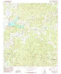
1984 Map of Mount Herman
USGS Topo · Published 1985About this map
Pinkston Reservoir dominates the western landscape of this Shelby County region, its irregular shoreline reaching into the drainages of Sandy Creek and Powdrill Creek. This early 1980s snapshot of east Texas reveals a rural territory transitioning through infrastructure development, notably seen at the Water Filtration Plant and a Radio Tower near the small community of Aiken. The settlement of Mount Herman sits centrally, surrounded by a dense network of seasonal and perennial waterways like Bog Creek and Little Iron Ore Creek that feed toward the southern county boundaries. The map documents the topographical character of the Piney Woods before more modern expansion, capturing several small water bodies such as Pearl Lake and Clear Lake alongside signs of local industry like a Gravel Pit near the headwaters of Caney Creek.
Find a feature on this map
23 named features on this map. Tap any name to fly to it.
Don’t see what you’re looking for? This feature index may not catch every label — zoom into the map to look around manually.
Map Details
Editions of this 1984 Mount Herman Map
This is the sole edition of this map. No revisions or reprints were ever made.
Other maps of this area

1953 · Palestine
USGS Topo · 1:250,000

1957 · Palestine
USGS Topo · 1:250,000

1958 · Center
USGS Topo · 1:62,500

1958 · San Augustine
USGS Topo · 1:62,500

1958 · Martinsville
USGS Topo · 1:62,500

1958 · Timpson
USGS Topo · 1:62,500

1984 · Palestine
USGS Topo · 1:250,000

1984 · Center
USGS Topo · 1:24,000
1984 · Chireno North
USGS Topo · 1:24,000
1984 · Garrison East
USGS Topo · 1:24,000