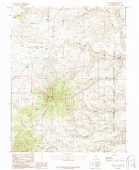
1987 Map of Mount Holmes
USGS Topo · Published 1987About this map
Mount Holmes stands as the central landmark in this high-desert landscape within the Henry Mountains and the Little Rockies. This 1980s-era topographic study reveals a land shaped by deep drainages, including Fourmile Canyon, Twomile Canyon, and Woodruff Canyon, all cutting toward the eastern boundary of the Glen Canyon National Recreation Area. Human activity is marked by scattered infrastructure, including an unnamed mine and adits located near Star Benches, and a series of 4WD tracks that provide access through the complex terrain. The map details vital water sources in an otherwise arid environment, such as Woodruff Spring and Hole Spring, which anchor the northern reaches near Woodruff Hole. To the east, the distinctive Hoskinnini Monument rises near the edge of Trachyte Creek, marking a significant geological feature on the canyon's rim.
Find a feature on this map
26 named features on this map. Tap any name to fly to it.
Don’t see what you’re looking for? This feature index may not catch every label — zoom into the map to look around manually.
Map Details
Editions of this 1987 Mount Holmes Map
This is the sole edition of this map. No revisions or reprints were ever made.
Other maps of this area

1886 · Henry Mountains
USGS Topo · 1:250,000

1892 · Henry Mountains
USGS Topo · 1:250,000

1952 · Mt Pennell 1 SW
USGS Topo · 1:24,000

1952 · Mancos Mesa
USGS Topo · 1:62,500

1952 · Mt Pennell 1 NE
USGS Topo · 1:24,000

1952 · Mt Hillers
USGS Topo · 1:62,500

1952 · Mt Pennell 1 SE
USGS Topo · 1:24,000

1952 · Mt Pennell 1 NW
USGS Topo · 1:24,000

1952 · Hite
USGS Topo · 1:62,500

1953 · Mt Pennell 4 NE
USGS Topo · 1:24,000