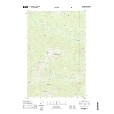
2020 Map of Mount Howard
USGS Topo · Published 2020About this map
The settlement of Berne sits along the southern edge of this map, serving as a critical waypoint for the New Cascade Tunnel as it cuts through the mountains. This 2020 survey illustrates the high-elevation terrain of the Wenatchee National Forest, where the Little Wenatchee River and Nason Cr define the drainage patterns between prominent peaks. Significant summits including Mt Howard, Mt Mastiff, and Rock Mtn create a sawtooth skyline, while the long stretch of Nason Ridge separates distinct alpine basins. Numerous high-country lakes are tucked into these ridges, notably Merritt Lake, Crescent Lake, and Lake Ethel near the Chiwaukum Mountains. The map also captures local recreation through the Big Tree Loop and various forest trails that navigate the complex geography between Wenatchee Ridge and the Arrowhead Mtn area.
Find a feature on this map
42 named features on this map. Tap any name to fly to it.
Don’t see what you’re looking for? This feature index may not catch every label — zoom into the map to look around manually.
Map Details
Editions of this 2020 Mount Howard Map
This is the sole edition of this map. No revisions or reprints were ever made.
Other maps of this area

1901 · Chiwaukum
USGS Topo · 1:125,000

1902 · Skykomish
USGS Topo · 1:125,000

1904 · Chiwaukum
USGS Topo · 1:125,000

1905 · Skykomish
USGS Topo · 1:125,000

1957 · Wenatchee
USGS Topo · 1:250,000

1965 · Chiwaukum Mts
USGS Topo · 1:62,500

1965 · Stevens Pass
USGS Topo · 1:24,000

1965 · Wenatchee Lake
USGS Topo · 1:62,500

1965 · Poe Mountain
USGS Topo · 1:24,000
1965 · Labyrinth Mtn
USGS Topo · 1:24,000