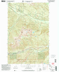
2004 Map of Mount Howard
USGS Topo · Published 2008About this map
Wenatchee National Forest dominates this high-altitude landscape in the central Cascades, where steep ridges and alpine lakes define the terrain. The northern reaches follow the Little Wenatchee River, punctuated by the localized activity at Soda Springs and a Quarry. Further south, the deep valley of Nason Creek provides a corridor for transportation and infrastructure, including a prominent Tunnel and the Berne area.
Find a feature on this map
51 named features on this map. Tap any name to fly to it.
Don’t see what you’re looking for? This feature index may not catch every label — zoom into the map to look around manually.
Map Details
Editions of this 2004 Mount Howard Map
This is the sole edition of this map. No revisions or reprints were ever made.
Other maps of this area

1901 · Chiwaukum
USGS Topo · 1:125,000

1902 · Skykomish
USGS Topo · 1:125,000

1904 · Chiwaukum
USGS Topo · 1:125,000

1905 · Skykomish
USGS Topo · 1:125,000

1957 · Wenatchee
USGS Topo · 1:250,000

1965 · Chiwaukum Mts
USGS Topo · 1:62,500

1965 · Stevens Pass
USGS Topo · 1:24,000

1965 · Wenatchee Lake
USGS Topo · 1:62,500

1965 · Poe Mountain
USGS Topo · 1:24,000
1965 · Labyrinth Mtn
USGS Topo · 1:24,000