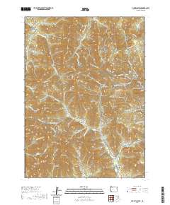
2020 Map of Mount Isabelle
USGS Topo · Published 2020About this map
Mt Isabelle rises above a landscape defined by its deep gulches and high ridges in this 2020 study of the Southern Oregon terrain. The area is heavily marked by its resource-extraction history, visible in features like the Old Miners site and a dense network of forest and timber roads such as Mainline Galls Creek Rd and Oregon Belle Loop Rd. High peaks including Timber Mtn and Sugarloaf overlook the drainage basins of Jackson Creek and Poormans Cr. Local history is anchored by the Log Town Cem in the southeast corner, reflecting the early settlement patterns of Jackson County. Recreation and water management are prominent throughout, with the Jacksonville Forest Park and its various routes like the Jackson Ridge Trail and Rail Trail winding through the hills near Jacksonville Reservoir.
Find a feature on this map
85 named features on this map. Tap any name to fly to it.
Don’t see what you’re looking for? This feature index may not catch every label — zoom into the map to look around manually.
Map Details
Editions of this 2020 Mount Isabelle Map
This is the sole edition of this map. No revisions or reprints were ever made.
Other maps of this area

1891 · Ashland
USGS Topo · 1:250,000

1893 · Ashland
USGS Topo · 1:250,000

1897 · Ashland
USGS Topo · 1:250,000

1908 · Grants Pass
USGS Topo · 1:125,000

1938 · Medford
USGS Topo · 1:125,000

1954 · Medford
USGS Topo · 1:62,500

1954 · Gold Hill
USGS Topo · 1:62,500

1954 · Talent
USGS Topo · 1:62,500

1954 · Ruch
USGS Topo · 1:62,500

1955 · Medford
USGS Topo · 1:250,000