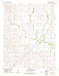
1979 Map of Mount Jesus
USGS Topo · Published 1980About this map
Mount Jesus and Mount Lookout rise above the drainage networks of central Kansas, anchoring a landscape defined by ranching and light aviation in the late 1970s. The township boundaries of Appleton and Lexington divide the territory, which is characterized by a complex system of waterways including Cat Creek, Fish Creek, and Granger Creek. A clear signal of the local agricultural economy is the presence of a large Feedlot and the private Seacat Bros Landing Strip, reflecting how large-scale land management utilized both the flats and the natural breaks provided by the Bluff formations. Notable infrastructure like pipelines and a Gravel Pit near the southern creeks indicate the extraction and transport activities that supported the region during this era.
Find a feature on this map
14 named features on this map. Tap any name to fly to it.
Don’t see what you’re looking for? This feature index may not catch every label — zoom into the map to look around manually.
Map Details
Editions of this 1979 Mount Jesus Map
2 editions found
Other maps of this area

1894 · Sitka
USGS Topo · 1:62,500

1896 · Ashland
USGS Topo · 1:125,000

1955 · Pratt
USGS Topo · 1:250,000

1959 · Pratt
USGS Topo · 1:250,000
1972 · Ashland
USGS Topo · 1:24,000

1979 · Sitka
USGS Topo · 1:24,000

1979 · Bloom SE
USGS Topo · 1:24,000

1979 · Sugarloaf
USGS Topo · 1:24,000

1979 · Turkey Creek
USGS Topo · 1:24,000
1979 · Simmons Creek
USGS Topo · 1:24,000