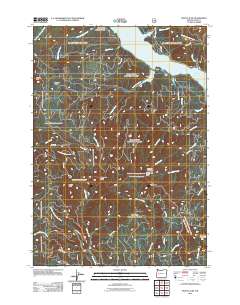
2011 Map of Mount June
USGS Topo · Published 2011About this map
Willamette National Frst defines the steep topography of this Lane County landscape, where the northern boundary meets the waters of Lookout Point Lake. This 2011 survey captures the area's intricate forest road network, including Usfs RD 17 and Usfs RD 5835, providing access to high-elevation landmarks such as Mount June and Hardesty Mountain. The presence of the Hardesty Lookout Tower and the Ash Swale Shelter reflects the region's managed wilderness character. Multiple drainages, including Junetta Creek, Herman Creek, and Patterson Creek, carve deep valleys between ridges, illustrating the complex watershed that feeds the larger lake system to the north. Historical markers such as Sawtooth Rock and Eagles Rest serve as distinct visual anchors for navigators and foresters within the heavy timber.
Find a feature on this map
40 named features on this map. Tap any name to fly to it.
Don’t see what you’re looking for? This feature index may not catch every label — zoom into the map to look around manually.
Map Details
Editions of this 2011 Mount June Map
This is the sole edition of this map. No revisions or reprints were ever made.
Other maps of this area

1935 · Lowell
USGS Topo · 1:96,000

1942 · Lowell
USGS Topo · 1:125,000

1955 · Hardesty Mtn
USGS Topo · 1:62,500

1955 · Fairview Peak
USGS Topo · 1:62,500

1955 · Culp Creek
USGS Topo · 1:62,500

1955 · Lowell
USGS Topo · 1:62,500

1958 · Roseburg
USGS Topo · 1:250,000

1959 · Roseburg
USGS Topo · 1:250,000

1983 · Oakridge
USGS Topo · 1:100,000
1986 · Saddleblanket Mountain
USGS Topo · 1:24,000