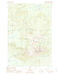
1988 Map of Mount Katahdin
USGS Topo · Published 1988About this map
Baxter State Park encompasses this high-elevation landscape, where the northern terminus of the Appalachian National Scenic Trail meets the dramatic peaks of Mt Katahdin. The topography is defined by massive glacial cirques like the Great Basin and the North Basin, which cradle high-altitude waters such as Chimney Pond and the Basin Ponds. A series of prominent ridges and peaks, including the razor-thin Knife Edge and the expansive Table Land, radiate from Baxter Peak. This map documents the complex drainage systems of Wassataquoik Stream and Katahdin Stream, featuring landmarks like Katahdin Stream Falls. In the lower elevations, the site of New City and the Katahdin Stream Campground suggest the area's development for backcountry recreation and forestry management in the late 20th century, while labels like The Klondike and The Gateway reflect the localized naming of specific mountain passages.
Find a feature on this map
60 named features on this map. Tap any name to fly to it.
Don’t see what you’re looking for? This feature index may not catch every label — zoom into the map to look around manually.
Map Details
Editions of this 1988 Mount Katahdin Map
2 editions found
Other maps of this area

1927 · Katahdin
USGS Topo · 1:48,000

1930 · Katahdin
USGS Topo · 1:62,500

1949 · Katahdin
USGS Topo · 1:62,500

1953 · Telos Lake
USGS Topo · 1:62,500

1954 · Harrington Lake
USGS Topo · 1:62,500

1954 · Presque Isle
USGS Topo · 1:250,000

1954 · Millinocket
USGS Topo · 1:250,000

1955 · Traveler Mountain
USGS Topo · 1:62,500

1957 · Telos Lake
USGS Topo · 1:62,500

1958 · Presque Isle
USGS Topo · 1:250,000