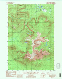
1988 Map of Mount Katahdin
USGS Topo · Published 1988About this map
Baxter Peak serves as the focal point for this survey of the northern Maine interior, showing the high-elevation terrain of Baxter State Park in the late 1980s. The map traces the famous Appalachian National Scenic Trail as it ascends toward the summit via Katahdin Stream. The topographic detail illustrates the glacial geology of the region, including the sheer walls of the North Basin and the Great Basin, and the narrow crossing of the Knife Edge connecting to Pamola.
Find a feature on this map
64 named features on this map. Tap any name to fly to it.
Don’t see what you’re looking for? This feature index may not catch every label — zoom into the map to look around manually.
Map Details
Editions of this 1988 Mount Katahdin Map
2 editions found
Other maps of this area

1927 · Katahdin
USGS Topo · 1:48,000

1930 · Katahdin
USGS Topo · 1:62,500

1949 · Katahdin
USGS Topo · 1:62,500

1953 · Telos Lake
USGS Topo · 1:62,500

1954 · Harrington Lake
USGS Topo · 1:62,500

1954 · Presque Isle
USGS Topo · 1:250,000

1954 · Millinocket
USGS Topo · 1:250,000

1955 · Traveler Mountain
USGS Topo · 1:62,500

1957 · Telos Lake
USGS Topo · 1:62,500

1958 · Presque Isle
USGS Topo · 1:250,000