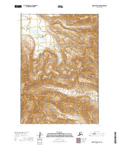
2019 Map of Mount Katmai A-5 SW
USGS Topo · Published 2019About this map
Katmai National Park and the Becharof National Wildlife Refuge meet in this wilderness region of the Alaska Peninsula, where the landscape is defined by the high elevations of the Kejulik Mountains. The terrain transitions from the steep slopes of the mountains in the south toward the drainage basins of the north, centered around the winding course of Takayofo Creek and its smaller tributary Takayofo Cr. This 2019 survey illustrates a rugged corridor of protected federal land before any major modern development, focusing instead on the natural topography and the strategic crossing at Kejulik Pass. Researchers can trace the hydrography and elevation contours that dictate movement through this remote part of the Lake and Peninsula Borough, providing a clear record of the ecological boundaries between these two major conservation areas.
Find a feature on this map
10 named features on this map. Tap any name to fly to it.
Don’t see what you’re looking for? This feature index may not catch every label — zoom into the map to look around manually.
Map Details
Editions of this 2019 Mount Katmai A-5 SW Map
This is the sole edition of this map. No revisions or reprints were ever made.
Other maps of this area

1948 · Mt Katmai
USGS Topo · 1:250,000

1951 · Mt Katmai
USGS Topo · 1:250,000

1951 · Karluk
USGS Topo · 1:250,000

1951 · Mount Katmai A-6
USGS Topo · 1:63,360

1951 · Karluk D-6
USGS Topo · 1:63,360

1951 · Karluk D-5
USGS Topo · 1:63,360

1951 · Mount Katmai A-5
USGS Topo · 1:63,360

1952 · Karluk
USGS Topo · 1:250,000

1964 · Mt. Katmai
USGS Topo · 1:250,000

1964 · Karluk
USGS Topo · 1:250,000