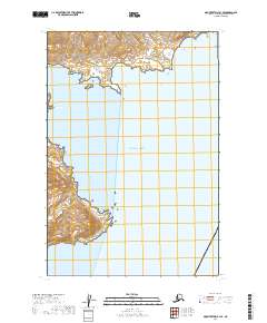
2019 Map of Mount Katmai B-1 SE
USGS Topo · Published 2019About this map
Katmai National Park encompasses the rugged coastline and mountainous terrain of this coastal Alaska region, where the steep slopes of the Aleutian Range meet the Pacific Ocean. This 2019 survey captures the untouched character of the peninsula, defined by significant maritime inlets and deep-water indentations that serve as natural landmarks. The map tracks the jagged shoreline from the northern waters of Kukak Bay down toward the southern entrance of Kaflia Bay, providing a clear view of the complex land-sea interface within the protected park boundaries. The contour lines reveal a landscape of sharp elevation changes directly adjacent to the tide, illustrating the geologic intensity of the Alaska Peninsula. These protected lands remain largely devoid of human infrastructure, focusing instead on the preservation of the natural wilderness and the marine environment of the North Pacific.
Find a feature on this map
7 named features on this map. Tap any name to fly to it.
Don’t see what you’re looking for? This feature index may not catch every label — zoom into the map to look around manually.
Map Details
Editions of this 2019 Mount Katmai B-1 SE Map
This is the sole edition of this map. No revisions or reprints were ever made.
Other maps of this area

1948 · Mt Katmai
USGS Topo · 1:250,000

1951 · Mt Katmai
USGS Topo · 1:250,000
1951 · Mount Katmai A-1
USGS Topo · 1:63,360

1951 · Mount Katmai B-1
USGS Topo · 1:63,360

1952 · Afognak
USGS Topo · 1:250,000

1964 · Mt. Katmai
USGS Topo · 1:250,000
2019 · Mount Katmai B-1 SW
USGS Topo · 1:25,000
2019 · Mount Katmai B-1 NW
USGS Topo · 1:25,000
2019 · Mount Katmai B-1 NE
USGS Topo · 1:25,000
2019 · Mount Katmai A-1 NW
USGS Topo · 1:25,000