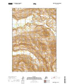
2019 Map of Mount Katmai C-2 SW
USGS Topo · Published 2019About this map
The glacial waters of the Savonoski River dominate the northern terrain of this wilderness area, flowing through the heart of Katmai National Park. The landscape is defined by extreme relief and active geological processes, anchored by the presence of Hook Glacier in the southeast. This 2019 survey documents the intricate drainage patterns and steep contour gradients of the Aleutian Range, where the river's path shifts through a broad valley floor surrounded by high peaks. The map provides a precise record of the physical geography within the Lake and Peninsula Borough, showing the intersection of Township 18 and 19 South, and Ranges 32 and 33 West.
Find a feature on this map
7 named features on this map. Tap any name to fly to it.
Don’t see what you’re looking for? This feature index may not catch every label — zoom into the map to look around manually.
Map Details
Editions of this 2019 Mount Katmai C-2 SW Map
This is the sole edition of this map. No revisions or reprints were ever made.
Other maps of this area

1948 · Mt Katmai
USGS Topo · 1:250,000

1951 · Mt Katmai
USGS Topo · 1:250,000

1951 · Mount Katmai C-3
USGS Topo · 1:63,360

1951 · Mount Katmai C-2
USGS Topo · 1:63,360

1951 · Mount Katmai B-3
USGS Topo · 1:63,360

1951 · Mount Katmai B-2
USGS Topo · 1:63,360
1953 · Mount Katmai C-2
USGS Topo · 1:63,360

1964 · Mt. Katmai
USGS Topo · 1:250,000
2019 · Mount Katmai C-2 NW
USGS Topo · 1:25,000
2019 · Mount Katmai B-2 NW
USGS Topo · 1:25,000