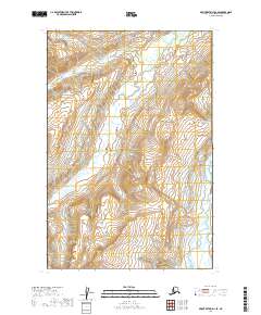
2019 Map of Mount Katmai D-2 SE
USGS Topo · Published 2019About this map
Katmai National Park encompasses the majority of this Alaskan wilderness terrain, characterized by steep elevation shifts and an intricate drainage system. The eastern boundary is marked by the Kamishak River, which flows through the rugged landscape of the Kenai Peninsula Borough. Throughout the central and northern sections of the survey, Strike Creek and its many branches, including labels for Strike Cr, dominate the local hydrography. The map provides a precise look at the township and range divisions, specifically t15s r31w and t16s r31w, illustrating how the federal public land survey system was applied to this remote interior. This 2019 data release emphasizes the natural watercourse patterns and topographic contours of the region before any major human development or infrastructure was established in these sections.
Find a feature on this map
8 named features on this map. Tap any name to fly to it.
Don’t see what you’re looking for? This feature index may not catch every label — zoom into the map to look around manually.
Map Details
Editions of this 2019 Mount Katmai D-2 SE Map
This is the sole edition of this map. No revisions or reprints were ever made.
Other maps of this area

1948 · Mt Katmai
USGS Topo · 1:250,000

1951 · Mt Katmai
USGS Topo · 1:250,000

1951 · Mount Katmai D-1
USGS Topo · 1:63,360

1951 · Mount Katmai C-2
USGS Topo · 1:63,360

1951 · Mount Katmai D-2
USGS Topo · 1:63,360

1951 · Mount Katmai C-1
USGS Topo · 1:63,360
1953 · Mount Katmai C-2
USGS Topo · 1:63,360
1953 · Mount Katmai D-1
USGS Topo · 1:63,360

1964 · Mt. Katmai
USGS Topo · 1:250,000
2019 · Mount Katmai C-2 NW
USGS Topo · 1:25,000