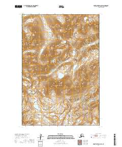
2019 Map of Mount Katmai D-2 SW
USGS Topo · Published 2019About this map
Katmai National Park dominates this terrain, showcasing the high-altitude topography of the Alaska Peninsula during the early twenty-first century. The landscape is defined by the steep elevation gradients of the Aleutian Range, where glacial meltwater feeds into the Kamishak River as it flows toward the coast. This 2019 survey documents the intricate drainage patterns of the region, including the headwaters of Strike Cr, which carves through the northwestern corner of the quadrangle. The map captures a moment of preserved wilderness within the Kenai Peninsula Borough, illustrating the complex interplay of snowfields and seasonal runoff within the park boundaries. Researchers can trace the formal township divisions, such as t15s r32w and t16s r32w, which overlay this largely roadless and uninhabited terrain.
Find a feature on this map
7 named features on this map. Tap any name to fly to it.
Don’t see what you’re looking for? This feature index may not catch every label — zoom into the map to look around manually.
Map Details
Editions of this 2019 Mount Katmai D-2 SW Map
This is the sole edition of this map. No revisions or reprints were ever made.
Other maps of this area

1948 · Mt Katmai
USGS Topo · 1:250,000

1951 · Mt Katmai
USGS Topo · 1:250,000

1951 · Mount Katmai C-3
USGS Topo · 1:63,360

1951 · Mount Katmai C-2
USGS Topo · 1:63,360

1951 · Mount Katmai D-2
USGS Topo · 1:63,360

1951 · Mount Katmai D-3
USGS Topo · 1:63,360
1953 · Mount Katmai C-2
USGS Topo · 1:63,360

1964 · Mt. Katmai
USGS Topo · 1:250,000
2019 · Mount Katmai C-2 NW
USGS Topo · 1:25,000
2019 · Mount Katmai C-2 NE
USGS Topo · 1:25,000