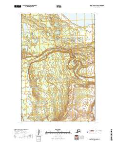
2019 Map of Mount Katmai D-5 NW
USGS Topo · Published 2019About this map
Katmai National Preserve and Katmai National Park meet in this remote region of the Alaska Peninsula, where the landscape is defined by the winding course of American Cr. The terrain is characterized by a high concentration of small lakes and ponds, particularly in the northern reaches where the waters of Nonvianuk Lake touch the boundary. The topographic detail highlights a complex network of wetlands and minor drainages that feed into these larger systems, illustrating the hydrological interconnectedness of the Lake and Peninsula Borough wilderness before significant modern infrastructure. This 2019 data illustrates the preserved state of the interior, showing no roads or established settlements within the surveyed sections.
Find a feature on this map
8 named features on this map. Tap any name to fly to it.
Don’t see what you’re looking for? This feature index may not catch every label — zoom into the map to look around manually.
Map Details
Editions of this 2019 Mount Katmai D-5 NW Map
This is the sole edition of this map. No revisions or reprints were ever made.
Other maps of this area

1948 · Mt Katmai
USGS Topo · 1:250,000

1951 · Mt Katmai
USGS Topo · 1:250,000

1951 · Mount Katmai D-5
USGS Topo · 1:63,360

1951 · Mount Katmai D-6
USGS Topo · 1:63,360

1951 · Iliamna A-7
USGS Topo · 1:63,360

1951 · Iliamna A-8
USGS Topo · 1:63,360

1952 · Iliamna
USGS Topo · 1:250,000
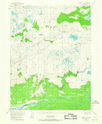
1952 · Iliamna A-8
USGS Topo · 1:63,360

1957 · Iliamna
USGS Topo · 1:250,000

1964 · Mt. Katmai
USGS Topo · 1:250,000