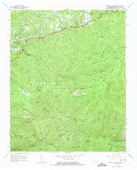
1964 Map of Mount Le Conte
USGS Topo · Published 1974About this map
Gatlinburg serves as the gateway to high-altitude landmarks in this mid-1960s survey of the Tennessee-North Carolina borderlands. The landscape is defined by the massive rise of Mount Le Conte, where Le Conte Lodge and Le Conte Lodge Spring sit near peaks like Cliff Top and Myrtle Point. Away from the main summits, the map documents the human history of the hollows through sites like the Ephraim Bales Place and Alfred Reagan Place, alongside several family burial grounds including McCarter Cem, Proffitt Cem, and Tudor Cem.
Find a feature on this map
106 named features on this map. Tap any name to fly to it.
Don’t see what you’re looking for? This feature index may not catch every label — zoom into the map to look around manually.
Map Details
Editions of this 1964 Mount Le Conte Map
4 editions found
Other maps of this area

1886 · Knoxville
USGS Topo · 1:125,000

1892 · Knoxville
USGS Topo · 1:125,000

1893 · Mt Guyot
USGS Topo · 1:125,000

1894 · Knoxville
USGS Topo · 1:125,000

1895 · Knoxville
USGS Topo · 1:125,000

1901 · Knoxville
USGS Topo · 1:125,000

1912 · Mt Guyot
USGS Topo · 1:125,000

1935 · English Mountain
USGS Topo · 1:48,000

1935 · Jones Cove
USGS Topo · 1:24,000

1935 · Richardson Cove
USGS Topo · 1:24,000