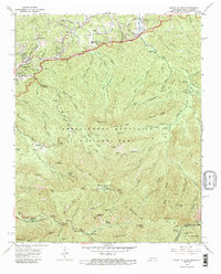
1964 Map of Mount Le Conte
USGS Topo · Published 1989About this map
Gatlinburg and the surrounding peaks of the Great Smoky Mountains National Park appear here during a period of established tourism and conserved wilderness. The map shows the transition from the bustling center of Gatlinburg to the primitive backcountry, highlighting the Gatlinburg-Pittman High School and local landmarks like the Open Air Theater. Climbing toward the high ridges, the survey details the rugged drainage systems of Roaring Fork and Baskins Creek.
Find a feature on this map
109 named features on this map. Tap any name to fly to it.
Don’t see what you’re looking for? This feature index may not catch every label — zoom into the map to look around manually.
Map Details
Editions of this 1964 Mount Le Conte Map
4 editions found
Other maps of this area

1886 · Knoxville
USGS Topo · 1:125,000

1892 · Knoxville
USGS Topo · 1:125,000

1893 · Mt Guyot
USGS Topo · 1:125,000

1894 · Knoxville
USGS Topo · 1:125,000

1895 · Knoxville
USGS Topo · 1:125,000

1901 · Knoxville
USGS Topo · 1:125,000

1912 · Mt Guyot
USGS Topo · 1:125,000

1935 · English Mountain
USGS Topo · 1:48,000

1935 · Jones Cove
USGS Topo · 1:24,000

1935 · Richardson Cove
USGS Topo · 1:24,000