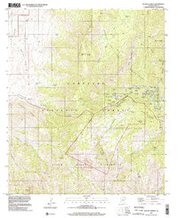
1996 Map of Mount Lemmon
USGS Topo · Published 2002About this map
Santa Catalina Mountains dominate this high-altitude landscape, where the seasonal retreats of Summerhaven and Loma Linda provide a cool refuge within the Coronado National Forest. This survey captures the area's transition from a historical mountain homesteading and mining site to a managed wilderness and scientific hub. The summit of Mt Lemmon is densely packed with infrastructure including an observatory, communication towers, and the Lemmon Rock Lookout, illustrating its strategic importance for both fire watching and astronomy. To the north and west, the terrain drops away through steep canyons like Sabino Canyon and Romero Canyon. Signs of early settlement persist at the Hartman Homestead and Catalina Camp, while the presence of Minas near the northern boundary points to the region's prospecting past before the establishment of the Santa Catalina Wilderness.
Find a feature on this map
75 named features on this map. Tap any name to fly to it.
Don’t see what you’re looking for? This feature index may not catch every label — zoom into the map to look around manually.
Map Details
Editions of this 1996 Mount Lemmon Map
This is the sole edition of this map. No revisions or reprints were ever made.
Other maps of this area

1904 · Tucson
USGS Topo · 1:125,000

1905 · Tucson
USGS Topo · 1:125,000

1911 · Winkelman
USGS Topo · 1:125,000

1913 · Winkelman
USGS Topo · 1:125,000

1948 · Mammoth
USGS Topo · 1:62,500

1948 · Campo Bonito
USGS Topo · 1:24,000

1949 · Campo Bonito
USGS Topo · 1:24,000
1951 · Mammoth
USGS Topo · 1:62,500

1956 · Tucson
USGS Topo · 1:250,000

1957 · Bellota Ranch
USGS Topo · 1:62,500