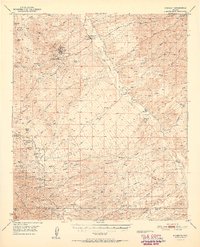
1951 Map of Mammoth
USGS Topo · Published 1951About this map
The copper-rich terrain of southern Pinal County is defined by the heavy industrial footprint of the Tiger and Mammoth mining districts. This 1951 survey documents the complex mining landscape just as the San Manuel Copper Mine was emerging as a major regional operation, surrounded by established workings like the Mohawk Mine and the Mammoth Mine. The San Pedro River valley acts as the central artery for the region, where numerous family-owned holdings like Clark Ranch and Sacaton Ranch occupy the fertile ground between the river and the rising Galiuro Mts. Further south, the high country transitions into the Coronado National Forest, where the settlement of Campo Bonito and several historic mines like the Southern Belle Mine sit in the shadows of Rice Pk. The presence of several Cemeteries and storied ranching headquarters like the American Flag Ranch provides a window into the varied layers of settlement in this arid landscape.
Find a feature on this map
58 named features on this map. Tap any name to fly to it.
Don’t see what you’re looking for? This feature index may not catch every label — zoom into the map to look around manually.
Map Details
Editions of this 1951 Mammoth Map
2 editions found
Other maps of this area

1904 · Tucson
USGS Topo · 1:125,000

1905 · Tucson
USGS Topo · 1:125,000

1911 · Winkelman
USGS Topo · 1:125,000

1913 · Winkelman
USGS Topo · 1:125,000

1938 · Galiuro Mts
USGS Topo · 1:48,000

1938 · Klondyke
USGS Topo · 1:48,000

1943 · Galiuro Mts
USGS Topo · 1:62,500

1943 · Klondyke
USGS Topo · 1:62,500

1945 · Redington
USGS Topo · 1:62,500

1948 · Clark Ranch
USGS Topo · 1:24,000