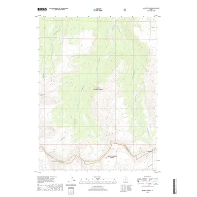
2020 Map of Mount Lovenia
USGS Topo · Published 2020About this map
Mt Lovenia stands as a primary landmark at the boundary of Summit and Duchesne counties, where the high drainage systems of the Uinta Mountains begin their descent. This 2020 survey details a transition point between the Wasatch National Forest and the Ashley National Forest, illustrating the intricate headwaters of the Middle Fork Blacks Fork and the E Fork Blacks Fork. These streams, along with the Little E Fork Blacks Fork, represent the high-altitude hydrology that feeds the larger regional basins. For those tracing historical transit through these peaks, the map marks the Uinta Highline trail and the crossing at Squaw Pass. The terrain is punctuated by significant summits like Tokewanna Peak and Bald Mtn, providing a precise look at the remote geography of the Uinta Range as it was recorded at the start of the 2020s.
Find a feature on this map
15 named features on this map. Tap any name to fly to it.
Don’t see what you’re looking for? This feature index may not catch every label — zoom into the map to look around manually.
Map Details
Editions of this 2020 Mount Lovenia Map
This is the sole edition of this map. No revisions or reprints were ever made.
Other maps of this area

1885 · Uinta
USGS Topo · 1:250,000

1901 · Hayden Peak
USGS Topo · 1:125,000

1903 · Hayden Peak
USGS Topo · 1:125,000

1905 · Gilbert Peak
USGS Topo · 1:125,000

1906 · Gilbert Peak
USGS Topo · 1:125,000

1954 · Salt Lake City
USGS Topo · 1:250,000

1958 · Salt Lake City
USGS Topo · 1:250,000

1960 · Salt Lake City
USGS Topo · 1:250,000

1967 · Explorer Peak
USGS Topo · 1:24,000
1967 · Mount Lovenia
USGS Topo · 1:24,000