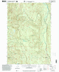
1997 Map of Mount Lowe
USGS Topo · Published 1999About this map
Rhododendron Ridge forms the high spine of this portion of the Mt Hood National Forest, dividing the complex drainages that feed into the Clackamas River and Collawash River. The 1997 revision of this landscape reveals a terrain defined by high-elevation meadows and industrial resource extraction. Named clearings like Jim Meadow, Rhododendron Meadow, and Eds Meadow dot the high country, while a series of gravel pits and quarries, including the Squirrel Quarry and Lowe Creek Pit, trace the network of forest roads. The presence of Graham Pass and Mount Lowe highlights the physical challenges of navigating this timber and watershed region. In the southern reaches, the isolated Round Lake sits near the border of Clackamas and Marion counties, providing a clear marker for those tracing land boundaries and drainage patterns in the northern Cascades.
Find a feature on this map
47 named features on this map. Tap any name to fly to it.
Don’t see what you’re looking for? This feature index may not catch every label — zoom into the map to look around manually.
Map Details
Editions of this 1997 Mount Lowe Map
This is the sole edition of this map. No revisions or reprints were ever made.
Other maps of this area

1916 · Estacada
USGS Topo · 1:125,000

1924 · Mount Hood
USGS Topo · 1:125,000

1927 · Mount Hood
USGS Topo · 1:125,000

1927 · Mt. Jefferson
USGS Topo · 1:125,000

1929 · Mill City
USGS Topo · 1:125,000

1930 · Mt. Jefferson
USGS Topo · 1:125,000

1948 · Vancouver
USGS Topo · 1:250,000

1950 · Vancouver
USGS Topo · 1:250,000

1950 · Vancouver
USGS Topo · 1:250,000

1953 · Salem
USGS Topo · 1:250,000