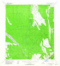
1952 Map of Mount McKinley C-3
USGS Topo · Published 1964About this map
The Kantishna Hills and Alpha Ridge define the southeastern corner of this Alaskan interior landscape, mapped from aerial photographs taken in 1952. The terrain is characterized by a complex drainage network, where the broad braided course of the McKinley River cuts across the southwest, while Moose Creek and Lower Moose Creek dominate the eastern drainage toward Canyon Creek. This area represents a remote wilderness prior to extensive modern infrastructure, evidenced by the presence of a primitive Winter Trail and a simple Trail crossing the northern reaches. Surveyed landmarks like Brooker Mtn and Reindeer Hill provide fixed points for navigating the high-relief topography. The map illustrates a transitional subarctic environment of glaciers, streams, and ridges, captured at a moment when human presence was limited to these few trails and named water bodies.
Find a feature on this map
12 named features on this map. Tap any name to fly to it.
Don’t see what you’re looking for? This feature index may not catch every label — zoom into the map to look around manually.
Map Details
Editions of this 1952 Mount McKinley C-3 Map
2 editions found
Other maps of this area

1952 · Mount McKinley
USGS Topo · 1:250,000

1952 · Mount McKinley B-2
USGS Topo · 1:63,360

1952 · Mount McKinley C-3
USGS Topo · 1:63,360

1952 · Mount McKinley C-2
USGS Topo · 1:63,360

1952 · Mount McKinley D-3
USGS Topo · 1:63,360

1953 · Mount McKinley B-4
USGS Topo · 1:63,360

1953 · Mount McKinley B-3
USGS Topo · 1:63,360

1953 · Mount McKinley C-4
USGS Topo · 1:63,360

1953 · Mount McKinley D-4
USGS Topo · 1:63,360

1954 · Mount McKinley C-4
USGS Topo · 1:63,360