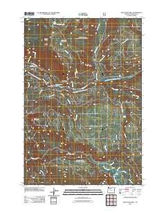
2011 Map of Mount Mitchell
USGS Topo · Published 2011About this map
Mount Mitchell and Oak Grove Butte anchor this high-elevation terrain in Clackamas County, where the hydrological system of the Clackamas River basin dominates the geography. The landscape is defined by the convergence of numerous waterways, including the Oak Grove Fork Clackamas River, which feeds into Lake Harriet behind the Harriet Dam. This water management infrastructure, coupled with the dense network of drainage systems like Lightning Creek and Shellrock Creek, reflects the region's importance for both natural resource preservation and hydroelectric utility.
Find a feature on this map
34 named features on this map. Tap any name to fly to it.
Don’t see what you’re looking for? This feature index may not catch every label — zoom into the map to look around manually.
Map Details
Editions of this 2011 Mount Mitchell Map
This is the sole edition of this map. No revisions or reprints were ever made.
Other maps of this area

1916 · Estacada
USGS Topo · 1:125,000

1924 · Mount Hood
USGS Topo · 1:125,000

1927 · Mount Hood
USGS Topo · 1:125,000

1927 · Mt. Jefferson
USGS Topo · 1:125,000

1929 · Mill City
USGS Topo · 1:125,000

1930 · Mt. Jefferson
USGS Topo · 1:125,000

1948 · Vancouver
USGS Topo · 1:250,000

1950 · Vancouver
USGS Topo · 1:250,000

1950 · Vancouver
USGS Topo · 1:250,000

1953 · Salem
USGS Topo · 1:250,000