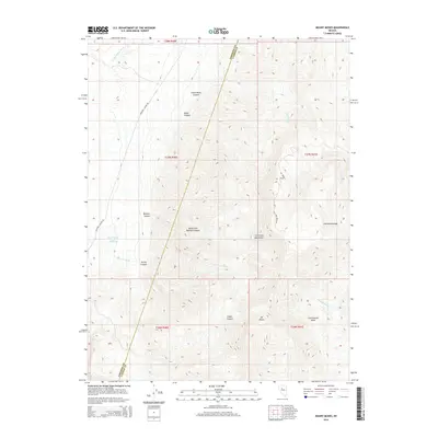
2014 Map of Mount Moses
USGS Topo · Published 2014About this map
Mt Moses dominates the southern landscape of this central Nevada terrain where the boundary between Pershing Co and Lander Co cuts diagonally across the Great Basin. This high-desert region is defined by the steep slopes of the Fish Creek Mountains, which drop off into the expansive Cottonwood Basin and Jersey Valley Wash. The sparse but vital water sources of the era are clearly marked, including the Hot Spring near Home Station Ranch and several drainages such as Cow Cr and Jersey Cr Wash. The presence of established routes like Butcher Canyon Rd and Fish Creek Rd suggests a landscape managed for ranching and transit through the high passes. Significant topographical features like Cottonwood Pass and North Fork Butcher Canyon illustrate the complex drainages and elevations that shaped local travel and land use in this part of the state.
Find a feature on this map
28 named features on this map. Tap any name to fly to it.
Don’t see what you’re looking for? This feature index may not catch every label — zoom into the map to look around manually.
Map Details
Editions of this 2014 Mount Moses Map
This is the sole edition of this map. No revisions or reprints were ever made.
Other maps of this area

1932 · Sonoma Range
USGS Topo · 1:250,000

1939 · Sonoma Range
USGS Topo · 1:250,000

1955 · Winnemucca
USGS Topo · 1:250,000

1958 · Winnemucca
USGS Topo · 1:250,000

1961 · Mt. Tobin
USGS Topo · 1:62,500

1961 · Cain Mountain
USGS Topo · 1:62,500

1961 · Mt. Moses
USGS Topo · 1:62,500

1962 · Winnemucca
USGS Topo · 1:250,000

1962 · Buffalo Springs
USGS Topo · 1:62,500

1982 · Fish Creek Mts
USGS Topo · 1:100,000