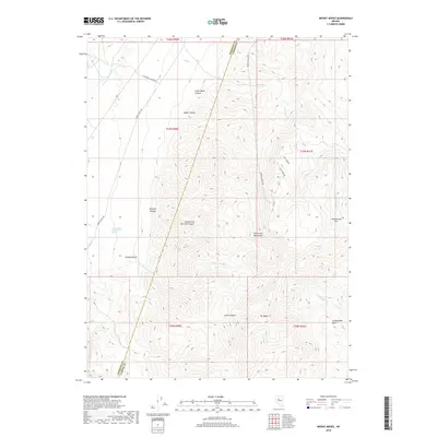
2018 Map of Mount Moses
USGS Topo · Published 2018About this map
Home Station Ranch Hot Spring sits at the edge of the Fish Creek Mountains in this high-desert portion of the Great Basin. The landscape is defined by the sharp transition from the flat expanse of Jersey Valley Wash to the complex drainages of the mountains, most notably Butcher Canyon and Cedar Canyon. This 2018 survey reveals the remote network of roads, including Jersey Valley Rd and Buffalo Valley Rd, that navigate the arid terrain between Lander and Pershing counties. The map provides a detailed view of the regional hydrology, tracing Jersey Cr Wash and the ephemeral Fish Cr as they move toward the basins below Mt Moses. Significant topographic features like Cottonwood Pass and Cottonwood Basin indicate the primary corridors through this rugged section of the Nevada interior.
Find a feature on this map
32 named features on this map. Tap any name to fly to it.
Don’t see what you’re looking for? This feature index may not catch every label — zoom into the map to look around manually.
Map Details
Editions of this 2018 Mount Moses Map
This is the sole edition of this map. No revisions or reprints were ever made.
Other maps of this area

1932 · Sonoma Range
USGS Topo · 1:250,000

1939 · Sonoma Range
USGS Topo · 1:250,000

1955 · Winnemucca
USGS Topo · 1:250,000

1958 · Winnemucca
USGS Topo · 1:250,000

1961 · Mt. Tobin
USGS Topo · 1:62,500

1961 · Cain Mountain
USGS Topo · 1:62,500

1961 · Mt. Moses
USGS Topo · 1:62,500

1962 · Winnemucca
USGS Topo · 1:250,000

1962 · Buffalo Springs
USGS Topo · 1:62,500

1982 · Fish Creek Mts
USGS Topo · 1:100,000