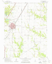
1974 Map of Mount Olive
USGS Topo · Published 1977About this map
The railroad town of Mount Olive serves as the focal point of this mid-1970s survey, showing a landscape defined by industrial infrastructure and local community institutions. Multiple rail lines, including the Norfolk and Western and Illinois Central Gulf, converge near the town center, where civic life is anchored by the City Hall, Post Office, and a series of educational buildings like High Sch and Jr High Sch. The presence of a Mine and Old RR Grade south of the main settlement points to the area's coal mining and transportation history along the Macoupin and Montgomery County line.
Find a feature on this map
39 named features on this map. Tap any name to fly to it.
Don’t see what you’re looking for? This feature index may not catch every label — zoom into the map to look around manually.
Map Details
Editions of this 1974 Mount Olive Map
This is the sole edition of this map. No revisions or reprints were ever made.
Other maps of this area

1912 · Gillespie
USGS Topo · 1:62,500

1915 · Gillespie
USGS Topo · 1:62,500

1915 · Mount Olive
USGS Topo · 1:62,500

1927 · Edwardsville
USGS Topo · 1:62,500

1932 · Edwardsville
USGS Topo · 1:62,500

1937 · New Douglas
USGS Topo · 1:48,000

1944 · New Douglas
USGS Topo · 1:62,500

1944 · Mount Olive
USGS Topo · 1:62,500

1954 · Worden
USGS Topo · 1:24,000
1954 · Edwardsville
USGS Topo · 1:62,500