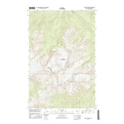
2017 Map of Mount Olympus
USGS Topo · Published 2017About this map
Mount Olympus and its neighboring summits of West Peak, East Peak, and Mid Peak form the high-altitude centerpiece of this topographical survey of Olympic National Park. The landscape is defined by its extensive glacial systems, with the massive Blue Glacier and Hubert Glacier carving the western slopes, while the Humes Glacier and Jeffers Glacier drain toward the south. These ice fields feed the headwaters of major regional waterways, including the Hoh River and the Queets River. For those tracing the geography of the high Olympics, the map identifies specific landmarks like Glacier Meadows, the high pass at Blizzard Pass, and Service Falls. The survey illustrates the complex drainage patterns where Glacier Cr and Falls Cr descend from the peaks toward the valley floor, providing a detailed record of the park's glaciated interior as it appeared in the early 21st century.
Find a feature on this map
31 named features on this map. Tap any name to fly to it.
Don’t see what you’re looking for? This feature index may not catch every label — zoom into the map to look around manually.
Map Details
Editions of this 2017 Mount Olympus Map
This is the sole edition of this map. No revisions or reprints were ever made.
Other maps of this area

1935 · Mount Olympus
USGS Topo · 1:62,500

1939 · Mount Tom
USGS Topo · 1:62,500

1942 · Mount Olympus
USGS Topo · 1:62,500

1947 · Mt Christie
USGS Topo · 1:62,500

1950 · Mt Christie
USGS Topo · 1:62,500

1950 · Hurricane Hill
USGS Topo · 1:24,000
1950 · Bogachiel Peak
USGS Topo · 1:24,000
1950 · Mount Carrie
USGS Topo · 1:24,000

1956 · Mount Olympus
USGS Topo · 1:62,500

1956 · Kloochman Rock
USGS Topo · 1:62,500