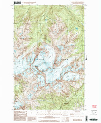
1999 Map of Mount Olympus
USGS Topo · Published 2003About this map
Mount Olympus stands as the dramatic centerpiece of this high-altitude survey, surrounded by the ice fields of Olympic National Park at the close of the twentieth century. The map documents an intricate glacial system including the massive Blue Glacier, White Glacier, and Hoh Glacier, which feed the headwaters of the Hoh River and Queets River. This technical study captures the extent of the permanent ice and snow features like the Snow Dome and the Humes Glacier before contemporary glacial retreat. Hikers and researchers can identify remote landmarks such as the shelters at Glacier Meadows and the steep traverses of Blizzard Pass and Glacier Pass. The terrain is marked by significant peaks, including Mount Mathias and the Middle Peak, providing a precise record of this alpine environment.
Find a feature on this map
24 named features on this map. Tap any name to fly to it.
Don’t see what you’re looking for? This feature index may not catch every label — zoom into the map to look around manually.
Map Details
Editions of this 1999 Mount Olympus Map
This is the sole edition of this map. No revisions or reprints were ever made.
Other maps of this area

1935 · Mount Olympus
USGS Topo · 1:62,500

1939 · Mount Tom
USGS Topo · 1:62,500

1942 · Mount Olympus
USGS Topo · 1:62,500

1947 · Mt Christie
USGS Topo · 1:62,500

1950 · Mt Christie
USGS Topo · 1:62,500

1950 · Hurricane Hill
USGS Topo · 1:24,000
1950 · Bogachiel Peak
USGS Topo · 1:24,000
1950 · Mount Carrie
USGS Topo · 1:24,000

1956 · Mount Olympus
USGS Topo · 1:62,500

1956 · Kloochman Rock
USGS Topo · 1:62,500