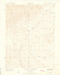
1949 Map of Mount Pittsburg
USGS Topo · Published 1949About this map
Mount Pittsburg anchors a high-altitude landscape defined by deep canyons and the convergence of three Colorado counties: Fremont, El Paso, and Pueblo. The late 1940s settlement pattern is characterized by remote pastoral operations, with Fords Mountaindale Ranch and Pinehurst Ranch situated along the drainage of Red Creek. The presence of the Red Creek School suggests a small but established community of ranching families in this frontier-like setting before modern consolidation changed the rural education landscape.
Find a feature on this map
25 named features on this map. Tap any name to fly to it.
Don’t see what you’re looking for? This feature index may not catch every label — zoom into the map to look around manually.
Map Details
Editions of this 1949 Mount Pittsburg Map
2 editions found
Other maps of this area

1889 · Canon City
USGS Topo · 1:125,000

1891 · Pueblo
USGS Topo · 1:125,000

1892 · Canon City
USGS Topo · 1:125,000

1893 · Colorado Springs
USGS Topo · 1:125,000

1894 · Pikes Peak
USGS Topo · 1:125,000

1894 · Pueblo
USGS Topo · 1:125,000

1896 · Pueblo
USGS Topo · 1:125,000

1897 · Pueblo
USGS Topo · 1:125,000

1901 · Pikes Peak
USGS Topo · 1:125,000

1909 · Colorado Springs
USGS Topo · 1:125,000