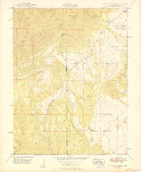
1949 Map of Mount Pittsburg
USGS Topo · Published 1949About this map
Mount Pittsburg and the surrounding high-altitude terrain at the intersection of Fremont, El Paso, and Pueblo Counties are defined by isolated ranching outposts and rugged drainages. The landscape is characterized by prominent peaks like Timber Mountain and Wild Mountain, with the low-lying Sullivan Park providing a rare break in the topography. At mid-century, this area supported a sparse network of family-held lands, including the Fords Mountaindale Ranch, Pinehurst Ranch, and Turkey Creek Ranch.
Find a feature on this map
25 named features on this map. Tap any name to fly to it.
Don’t see what you’re looking for? This feature index may not catch every label — zoom into the map to look around manually.
Map Details
Editions of this 1949 Mount Pittsburg Map
2 editions found
Other maps of this area

1889 · Canon City
USGS Topo · 1:125,000

1891 · Pueblo
USGS Topo · 1:125,000

1892 · Canon City
USGS Topo · 1:125,000

1893 · Colorado Springs
USGS Topo · 1:125,000

1894 · Pikes Peak
USGS Topo · 1:125,000

1894 · Pueblo
USGS Topo · 1:125,000

1896 · Pueblo
USGS Topo · 1:125,000

1897 · Pueblo
USGS Topo · 1:125,000

1901 · Pikes Peak
USGS Topo · 1:125,000

1909 · Colorado Springs
USGS Topo · 1:125,000