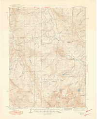
1940 Map of Mount Powell
USGS Topo · Published 1949About this map
The Blue River carves a central path through this high-altitude landscape, where the boundaries of Grand, Eagle, and Summit counties meet. Surveyed in the early 1930s, the map reveals a remote ranching economy centered around family holdings such as the Noonan Ranch, Abbet Place, and Smith Ranch. These isolated homesteads were connected by the Gore Pass Road and supported by the small Hillcrest Sch, reflecting the sparse but resilient settlement patterns of the interwar era before modern highway developments.
Find a feature on this map
73 named features on this map. Tap any name to fly to it.
Don’t see what you’re looking for? This feature index may not catch every label — zoom into the map to look around manually.
Map Details
Editions of this 1940 Mount Powell Map
3 editions found
Other maps of this area

1929 · Dillon
USGS Topo · 1:62,500

1933 · Mt. Powell
USGS Topo · 1:48,000

1933 · Ute Peak
USGS Topo · 1:62,500

1934 · Minturn
USGS Topo · 1:62,500

1934 · Dillon
USGS Topo · 1:62,500

1937 · Ute Peak
USGS Topo · 1:62,500

1940 · Mount Powell
USGS Topo · 1:62,500

1950 · Minturn
USGS Topo · 1:62,500

1954 · Craig
USGS Topo · 1:250,000

1956 · Kremmling
USGS Topo · 1:62,500