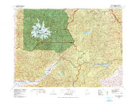
1978 Map of Mount Rainier
USGS Topo · Published 1978About this map
Mt Rainier dominates this 1978 survey, its glacial system radiating from the summit with massive ice fields like Emmons Glacier and Winthrop Glacier clearly delineated. The map details a landscape of high alpine peaks and deep river valleys, showing the intersection of Mount Rainier National Park with the surrounding Gifford Pinchot, Snoqualmie, and Wenatchee National Forests.
Find a feature on this map
78 named features on this map. Tap any name to fly to it.
Don’t see what you’re looking for? This feature index may not catch every label — zoom into the map to look around manually.
Map Details
Editions of this 1978 Mount Rainier Map
2 editions found
Other maps of this area

1897 · Mount Stuart
USGS Topo · 1:125,000

1897 · Tacoma
USGS Topo · 1:125,000

1899 · Ellensburg
USGS Topo · 1:125,000

1900 · Tacoma
USGS Topo · 1:125,000

1901 · Ellensburg
USGS Topo · 1:125,000

1901 · Snoqualmie Pass
USGS Topo · 1:125,000

1902 · Mount Aix
USGS Topo · 1:125,000

1902 · Mount Stuart
USGS Topo · 1:125,000

1903 · Snoqualmie
USGS Topo · 1:125,000

1904 · Mt Aix
USGS Topo · 1:125,000