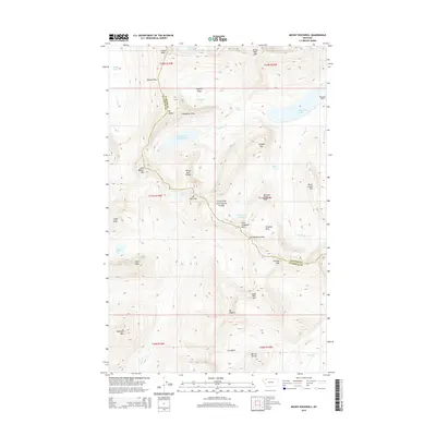
2014 Map of Mount Rockwell
USGS Topo · Published 2014About this map
Glacier National Park dominates this high-altitude terrain, showcasing the continental divide and the complex hydrology of the Lewis Range. The glacial legacy is evident in the chain of water bodies flowing through the eastern valleys, including Two Medicine Lake, Upper Two Medicine Lake, and the smaller No Name Lake. This landscape is defined by its massive peaks and ridges, where Mt Rockwell and Sinopah Mtn tower over the Two Medicine Creek drainage. Key transit points for early explorers and modern hikers alike are documented here, such as Dawson Pass in the north and Two Medicine Pass to the south. The map provides a detailed view of these natural corridors and the distinct landmarks like Pumpelly Pillar and Painted Tepee Peak that served as navigational beacons in this alpine environment before the era of modern mapping.
Find a feature on this map
50 named features on this map. Tap any name to fly to it.
Don’t see what you’re looking for? This feature index may not catch every label — zoom into the map to look around manually.
Map Details
Editions of this 2014 Mount Rockwell Map
This is the sole edition of this map. No revisions or reprints were ever made.
Other maps of this area
1901 · Browning
USGS Topo · 1:125,000
1903 · Browning
USGS Topo · 1:125,000
1904 · Chief Mountain
USGS Topo · 1:125,000
1913 · Marias Pass
USGS Topo · 1:125,000
1914 · Nyack
USGS Topo · 1:125,000
1938 · Chief Mountain
USGS Topo · 1:125,000
1960 · Cut Bank
USGS Topo · 1:250,000
1963 · Cut Bank
USGS Topo · 1:250,000
1964 · Cut Bank
USGS Topo · 1:250,000
1964 · Essex
USGS Topo · 1:24,000