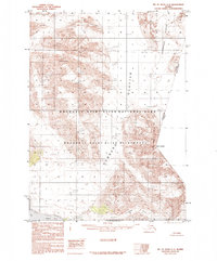
1985 Map of Mount Saint Elias A-4
USGS Topo · Published 1985About this map
Hubbard Glacier dominates this high-altitude landscape along the Alaska-Yukon Territory border, where massive ice fields meet the saltwater of Disenchantment Bay. The map records a wilderness of extreme vertical relief, anchored by prominent peaks like Mount Foresta and Mount Seattle. This 1985 survey captures the extent of the Wrangell-Saint Elias National Park and the adjacent Wrangell-Saint Elias Wilderness at a time when the region was primarily accessible only by air or sea. The southern edge of the sheet provides a detailed view of the complex Shoreline and the glacial Moraine deposits that characterize the entrance to Russell Fiord, illustrating the dynamic nature of this northern ice-field environment before modern climate shifts significantly altered these coastal margins.
Find a feature on this map
16 named features on this map. Tap any name to fly to it.
Don’t see what you’re looking for? This feature index may not catch every label — zoom into the map to look around manually.
Map Details
Editions of this 1985 Mount Saint Elias A-4 Map
This is the sole edition of this map. No revisions or reprints were ever made.
Other maps of this area

1951 · Yakutat
USGS Topo · 1:250,000

1951 · Mt Saint Elias
USGS Topo · 1:250,000

1959 · Yakutat D-3
USGS Topo · 1:63,360

1959 · Yakutat D-4
USGS Topo · 1:63,360

1959 · Yakutat D-5
USGS Topo · 1:63,360

1959 · Yakutat
USGS Topo · 1:250,000

1959 · Mt Saint Elias
USGS Topo · 1:250,000
1985 · Mount Saint Elias A-5
USGS Topo · 1:63,360
1985 · Mount Saint Elias B-4
USGS Topo · 1:63,360
1985 · Mount Saint Elias B-3
USGS Topo · 1:63,360