
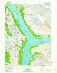
1959 Map of Yakutat D-4
USGS Topo · Published 1963About this map
Russell Fiord and the surrounding wilderness of the Tongass National Forest dominate this 1959 survey of the Alaskan coastline. The landscape is defined by the massive glacial systems that feed into the tidal waters, including the expansive Variegated Glacier and Orange Glacier to the north, and the McCarty Glacier and Hendrickson Glacier to the west. These ice flows carve the steep terrain between peaks like Mount McCarty and Rasmusson Mountain. Coastal features such as Gilbert Point and Cape Enchantment mark the narrow passages where the ice meets the sea. The map provides a detailed look at the hydrography of Nunatak Fiord and Disenchantment Bay, where Osier Island sits at the head of the inlet, illustrating the state of these retreating glaciers and the resulting shoreline just before the 1960s.
Find a feature on this map
23 named features on this map. Tap any name to fly to it.
Don’t see what you’re looking for? This feature index may not catch every label — zoom into the map to look around manually.
Map Details
Editions of this 1959 Yakutat D-4 Map
2 editions found
Other maps of this area

1951 · Yakutat
USGS Topo · 1:250,000

1951 · Mt Saint Elias
USGS Topo · 1:250,000

1959 · Yakutat C-3
USGS Topo · 1:63,360

1959 · Yakutat D-3
USGS Topo · 1:63,360

1959 · Yakutat C-5
USGS Topo · 1:63,360

1959 · Yakutat C-4
USGS Topo · 1:63,360

1959 · Yakutat D-5
USGS Topo · 1:63,360

1959 · Yakutat
USGS Topo · 1:250,000

1959 · Mt Saint Elias
USGS Topo · 1:250,000
1985 · Mount Saint Elias A-5
USGS Topo · 1:63,360