
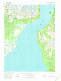
1959 Map of Yakutat D-5
USGS Topo · Published 1964About this map
Tongass National Forest dominates the rugged eastern shoreline of this coastal Alaskan landscape, where the waters of Yakutat Bay meet the massive ice flows of the Saint Elias Mountains. Massive glaciers such as the Lucia Glacier, Atrevida Glacier, and Galiano Glacier terminate at the water's edge, carving out a dynamic coastline of inlets and sediment-heavy outflows like the Strawberry Wash and Grand River.
Find a feature on this map
24 named features on this map. Tap any name to fly to it.
Don’t see what you’re looking for? This feature index may not catch every label — zoom into the map to look around manually.
Map Details
Editions of this 1959 Yakutat D-5 Map
2 editions found
Other maps of this area

1951 · Yakutat
USGS Topo · 1:250,000

1951 · Mt Saint Elias
USGS Topo · 1:250,000

1959 · Yakutat C-5
USGS Topo · 1:63,360

1959 · Yakutat D-4
USGS Topo · 1:63,360

1959 · Yakutat C-4
USGS Topo · 1:63,360

1959 · Yakutat
USGS Topo · 1:250,000

1959 · Mt Saint Elias
USGS Topo · 1:250,000
1985 · Mount Saint Elias A-5
USGS Topo · 1:63,360
1985 · Yakutat D-6
USGS Topo · 1:63,360
1985 · Mount Saint Elias A-4
USGS Topo · 1:63,360