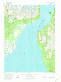
1959 Map of Yakutat D-5
USGS Topo · Published 1974About this map
Atrevida Glacier and the massive Lucia Glacier dominate the northern landscape of this coastal survey, where ice meets the tide-water of Disenchantment Bay. The map reveals a dynamic glacial environment, characterized by features such as Amphitheater Knob and the braided outflows of Grand Wash and Strawberry Wash. Within the Tongass National Forest, steep coastal bluffs like Logan Bluffs descend toward the deep waters of Yakutat Bay. The absence of roads or trails emphasizes the isolation of this region in the mid-20th century. Researchers can study the historical positions of the Latouche Glacier and Galiano Glacier, or trace the coastline past Haenke Island to Bancas Point, providing a primary record of the terrain before decades of contemporary glacial recession.
Find a feature on this map
28 named features on this map. Tap any name to fly to it.
Don’t see what you’re looking for? This feature index may not catch every label — zoom into the map to look around manually.
Map Details
Editions of this 1959 Yakutat D-5 Map
2 editions found
Other maps of this area

1951 · Yakutat
USGS Topo · 1:250,000

1951 · Mt Saint Elias
USGS Topo · 1:250,000

1959 · Yakutat C-5
USGS Topo · 1:63,360

1959 · Yakutat D-4
USGS Topo · 1:63,360

1959 · Yakutat C-4
USGS Topo · 1:63,360

1959 · Yakutat D-5
USGS Topo · 1:63,360

1959 · Yakutat
USGS Topo · 1:250,000

1959 · Mt Saint Elias
USGS Topo · 1:250,000
1985 · Mount Saint Elias A-5
USGS Topo · 1:63,360
1985 · Yakutat D-6
USGS Topo · 1:63,360