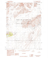
1985 Map of Mount Saint Elias A-8
USGS Topo · Published 1985About this map
Glacial movement and high-latitude terrain dominate this landscape at the edge of the Canada United States border. The massive Malaspina Glacier spreads across the southern portion of the quadrangle, fed by the descending flows of the Libbey Glacier and Agassiz Glacier. These ice fields are punctuated by rocky formations like the Samovar Hills and Chaix Hills, which stand as prominent nunataks amidst the shifting ice. A rare point of named human interest in this wilderness is Moore Nunatak, a isolated peak surrounded by snow fields.
Find a feature on this map
12 named features on this map. Tap any name to fly to it.
Don’t see what you’re looking for? This feature index may not catch every label — zoom into the map to look around manually.
Map Details
Editions of this 1985 Mount Saint Elias A-8 Map
This is the sole edition of this map. No revisions or reprints were ever made.
Other maps of this area

1950 · Bering Glacier
USGS Topo · 1:250,000

1950 · Icy Bay
USGS Topo · 1:250,000

1951 · Icy Bay
USGS Topo · 1:250,000

1951 · Bering Glacier
USGS Topo · 1:250,000

1951 · Yakutat
USGS Topo · 1:250,000

1951 · Mt Saint Elias
USGS Topo · 1:250,000

1959 · Yakutat
USGS Topo · 1:250,000

1959 · Bering Glacier
USGS Topo · 1:250,000

1959 · Mt Saint Elias
USGS Topo · 1:250,000

1961 · Icy Bay
USGS Topo · 1:250,000