1961 Map of Icy Bay
USGS Topo · Published 1966About this map
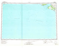
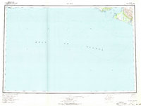
The Malaspina Glacier dominates the eastern coastline of this maritime survey, illustrating the dynamic glacial landscape where ice meets the Gulf of Alaska. Near the entrance to Icy Bay, the map documents a sparse human presence through isolated cabins and a drill hole, indicating early exploration or resource surveying in this remote reach. The intricate coastline is defined by features like Icy Cape and Pt Riou, while Moraine I and Moraine Reef signal the massive depositional work of the advancing and retreating ice. Several glacial meltwater systems, including the Priest River and Big River, feed into the bay. To the west, the boundary of the Chugach Nat Forest begins near Cape Suckling, marking the transition into protected coastal wilderness.
Find a feature on this map
19 named features on this map. Tap any name to fly to it.
Don’t see what you’re looking for? This feature index may not catch every label — zoom into the map to look around manually.
Map Details
Editions of this 1961 Icy Bay Map
3 editions found

Other maps of this area

1948 · Cordova
USGS Topo · 1:250,000

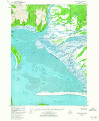
1948 · Icy Bay D-2 and D-3
USGS Topo · 1:63,360

1948 · Middleton Island
USGS Topo · 1:250,000

1948 · Bering Glacier A-4
USGS Topo · 1:63,360

1950 · Middleton Island
USGS Topo · 1:250,000

1950 · Bering Glacier A-3
USGS Topo · 1:63,360

1950 · Bering Glacier
USGS Topo · 1:250,000

1950 · Icy Bay
USGS Topo · 1:250,000
1950 · Cordova A-1
USGS Topo · 1:63,360

1951 · Icy Bay D-2 and D-3
USGS Topo · 1:63,360