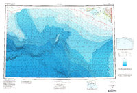
1961 Map of Icy Bay
USGS Topo · Published 1984About this map
The massive Malaspina Glacier dominates the eastern edge of this coastal survey, where the icy flow meets the intricate shoreline of Icy Bay. This topographic-bathymetric study captures the complex interface of land and sea in a period when new federal land protections were being codified. Along the shores of Riou Bay and Guyot Bay, the landscape is defined by glacial features like Moraine Reef and prominent landmarks such as Claybluff Pt and Tsimpshian Point. Marine researchers can trace the contours of the Pam Piona Spur rising from the floor of the Gulf of Alaska, while on land, the map documents isolated Cabins and a Landing Strip serving this wilderness region. The boundary of Wrangell-Saint Elias National Park reflects the 1980 expansion of Alaska's protected interior, juxtaposed with the Chugach Nat Forest to the west.
Find a feature on this map
19 named features on this map. Tap any name to fly to it.
Don’t see what you’re looking for? This feature index may not catch every label — zoom into the map to look around manually.
Map Details
Editions of this 1961 Icy Bay Map
3 editions found

Other maps of this area

1948 · Cordova
USGS Topo · 1:250,000

1948 · Icy Bay D-2 and D-3
USGS Topo · 1:63,360

1948 · Middleton Island
USGS Topo · 1:250,000

1948 · Bering Glacier A-4
USGS Topo · 1:63,360

1950 · Middleton Island
USGS Topo · 1:250,000

1950 · Bering Glacier A-3
USGS Topo · 1:63,360

1950 · Bering Glacier
USGS Topo · 1:250,000

1950 · Icy Bay
USGS Topo · 1:250,000

1950 · Cordova A-1
USGS Topo · 1:63,360

1951 · Icy Bay D-2 and D-3
USGS Topo · 1:63,360