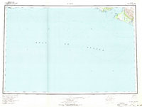
1961 Map of Icy Bay
USGS Topo · Published 1971About this map
Malaspina Glacier dominates the northeastern corner of this coastal survey, where massive ice flows meet the waters of the Gulf of Alaska. The landscape is defined by dynamic glacial recession and hydraulic action, as seen in the braided network of the Yahtse River and Vana Stream pouring from the ice front. Along the western edge of Icy Bay, a cluster of cabins and a designated Landing Area near Icy Cape indicate the sparse, temporary human presence in this wilderness during the mid-20th century.
Find a feature on this map
22 named features on this map. Tap any name to fly to it.
Don’t see what you’re looking for? This feature index may not catch every label — zoom into the map to look around manually.
Map Details
Editions of this 1961 Icy Bay Map
3 editions found

Other maps of this area

1948 · Cordova
USGS Topo · 1:250,000

1948 · Icy Bay D-2 and D-3
USGS Topo · 1:63,360

1948 · Middleton Island
USGS Topo · 1:250,000

1948 · Bering Glacier A-4
USGS Topo · 1:63,360

1950 · Middleton Island
USGS Topo · 1:250,000

1950 · Bering Glacier A-3
USGS Topo · 1:63,360

1950 · Bering Glacier
USGS Topo · 1:250,000

1950 · Icy Bay
USGS Topo · 1:250,000

1950 · Cordova A-1
USGS Topo · 1:63,360

1951 · Icy Bay D-2 and D-3
USGS Topo · 1:63,360