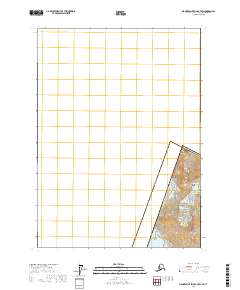
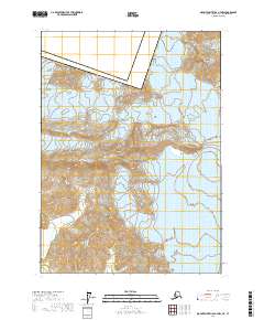
2017 Map of Mount Saint Elias B-7 SW
USGS Topo · Published 2017About this map
Wrangell-Saint Elias National Park dominates the southeastern quadrant of this map, representing a portion of the vast glacial and mountainous landscape within Yakutat Borough. The topography is defined by the high peaks of the Saint Elias Mountains, where steep contour lines lead to the summit of Mt Augusta on the international boundary between Alaska and Canada. This high-altitude terrain transitions into the icy expanse of the Malaspina Glacier at lower elevations. The survey illustrates the complex border geometry where the United States of America meets Yukon Territory, a region defined more by its massive ice fields and vertical relief than by human settlement. The absence of roads or structures highlights the wilderness character of the region, where only the PLSS grid lines of t19s r28e and t19s r29e provide a human-defined reference for this remote alpine environment.
Find a feature on this map
10 named features on this map. Tap any name to fly to it.
Don’t see what you’re looking for? This feature index may not catch every label — zoom into the map to look around manually.
Map Details
Editions of this 2017 Mount Saint Elias B-7 SW Map
This is the sole edition of this map. No revisions or reprints were ever made.
Other maps of this area

1951 · Mt Saint Elias
USGS Topo · 1:250,000

1959 · Mt Saint Elias
USGS Topo · 1:250,000
1985 · Mount Saint Elias A-7
USGS Topo · 1:63,360
1985 · Mount Saint Elias B-7
USGS Topo · 1:63,360
1985 · Mount Saint Elias A-8
USGS Topo · 1:63,360
1985 · Mount Saint Elias B-8
USGS Topo · 1:63,360
2017 · Mount Saint Elias A-8 NE
USGS Topo · 1:25,000
2017 · Mount Saint Elias B-7 SE
USGS Topo · 1:25,000
2017 · Mount Saint Elias A-7 NE
USGS Topo · 1:25,000
2017 · Mount Saint Elias A-7 NW
USGS Topo · 1:25,000