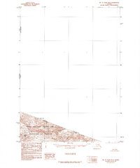
1985 Map of Mount Saint Elias B-8
USGS Topo · Published 1985About this map
Mt St Elias stands as the towering focal point along the international border in this mid-1980s topographic study. The map documents the high-altitude boundary between Alaska and the Yukon Territory, where the United States and Canada meet. This provisional edition, based on aerial photography from the early 1960s, highlights the ice-covered expanses of a massive Glacier flowing through the southern portion of the quadrangle. Most of the land shown is protected within the Wrangell-Saint Elias National Park and the adjacent Wrangell-Saint Elias Wilderness. The terrain is defined by extreme relief, including the summit of Haydon Peak, in a region where the road legend explicitly notes that no roads or trails existed at the time of publication.
Find a feature on this map
9 named features on this map. Tap any name to fly to it.
Don’t see what you’re looking for? This feature index may not catch every label — zoom into the map to look around manually.
Map Details
Editions of this 1985 Mount Saint Elias B-8 Map
This is the sole edition of this map. No revisions or reprints were ever made.
Other maps of this area

1950 · Bering Glacier
USGS Topo · 1:250,000

1951 · Bering Glacier
USGS Topo · 1:250,000

1951 · Mt Saint Elias
USGS Topo · 1:250,000

1959 · Bering Glacier
USGS Topo · 1:250,000

1959 · Mt Saint Elias
USGS Topo · 1:250,000
1985 · Mount Saint Elias A-7
USGS Topo · 1:63,360
1985 · Mount Saint Elias B-7
USGS Topo · 1:63,360
1985 · Bering Glacier B-1
USGS Topo · 1:63,360
1985 · Bering Glacier C-1
USGS Topo · 1:63,360
1985 · Mount Saint Elias A-8
USGS Topo · 1:63,360