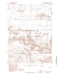
1985 Map of Bering Glacier B-1
USGS Topo · Published 1985About this map
The Wrangell-Saint Elias National Park and Wrangell-Saint Elias Wilderness dominate this high-altitude landscape along the border between the Alaska Yukon Territory and the United States Canada international line. This 1985 provisional survey documents a region of massive ice and rock, characterized by the expansive Bagley Icefield and Columbus Glacier. Prominent peaks and formations such as Mount Huxley, Table Mtn, and The Hump rise above the surrounding ice, serving as critical landmarks for navigation and mapping in this ice-bound corridor. The map captures the complex drainage patterns of the Quintino Sella and the deep depression of Crater Basin, illustrating the powerful glacial forces that have shaped the Saint Elias Mountains.
Find a feature on this map
12 named features on this map. Tap any name to fly to it.
Don’t see what you’re looking for? This feature index may not catch every label — zoom into the map to look around manually.
Map Details
Editions of this 1985 Bering Glacier B-1 Map
This is the sole edition of this map. No revisions or reprints were ever made.
Other maps of this area

1950 · Bering Glacier
USGS Topo · 1:250,000

1951 · Bering Glacier
USGS Topo · 1:250,000

1951 · Bering Glacier A-2
USGS Topo · 1:63,360

1951 · Mt Saint Elias
USGS Topo · 1:250,000

1959 · Bering Glacier
USGS Topo · 1:250,000

1959 · Mt Saint Elias
USGS Topo · 1:250,000

1959 · Bering Glacier A-2
USGS Topo · 1:63,360
1985 · Bering Glacier C-2
USGS Topo · 1:63,360
1985 · Bering Glacier C-1
USGS Topo · 1:63,360
1985 · Mount Saint Elias A-8
USGS Topo · 1:63,360