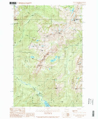
1990 Map of Mount Skokomish
USGS Topo · Published 1990About this map
Mount Skokomish and the high peaks of the Sawtooth Ridge define this mountain landscape within the Olympic National Park and the adjacent Mount Skokomish Wilderness. The 1990 survey captures the rugged hydrology of the region, where the North Fork Skokomish River winds past Staircase Rapids toward the northern tip of Lake Cushman. Remote outposts such as Nine Stream Camp, Camp Pleasant, and the Staircase Ranger Station provide the primary human anchors in a territory dominated by steep drainage systems like Hammer Creek and Madeline Creek. Local history is preserved in the location of the Darky Mine and the naming of summits like Mount Henderson and Mount Ellinor. The map traces an intricate network of alpine water bodies, including the Mildred Lakes and Flapjack Lakes, connected by the Donahue Creek Trail.
Find a feature on this map
46 named features on this map. Tap any name to fly to it.
Don’t see what you’re looking for? This feature index may not catch every label — zoom into the map to look around manually.
Map Details
Editions of this 1990 Mount Skokomish Map
This is the sole edition of this map. No revisions or reprints were ever made.
Other maps of this area

1938 · Mt Constance
USGS Topo · 1:125,000

1943 · Potlatch
USGS Topo · 1:62,500

1947 · The Brothers
USGS Topo · 1:62,500

1947 · Mt. Steel
USGS Topo · 1:62,500

1950 · The Brothers
USGS Topo · 1:62,500

1950 · Mt. Steel
USGS Topo · 1:62,500

1952 · Potlatch
USGS Topo · 1:62,500

1953 · Mt Tebo
USGS Topo · 1:62,500

1958 · Seattle
USGS Topo · 1:250,000

1962 · Seattle
USGS Topo · 1:250,000