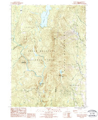
1986 Map of Mount Snow
USGS Topo · Published 1987About this map
Green Mountain National Forest dominates this mid-1980s landscape, where industrial water management and alpine recreation converge in Windham and Bennington Counties. The massive Somerset Reservoir to the north and the Searsburg Reservoir to the south illustrate the engineering of the Deerfield River watershed for power and storage. Between these points, the heights of Mount Snow and Haystack Mountain mark the significant elevation changes of the Green Mountains. Small settlements like Somerset and Searsburg remain isolated amid the timber and terrain, while smaller water bodies such as Haystack Pond and Crystal Pond sit tucked into the high ridges. This era of the map shows the transition from a purely industrial timber and water landscape to one increasingly defined by the burgeoning winter sports industry.
Find a feature on this map
34 named features on this map. Tap any name to fly to it.
Don’t see what you’re looking for? This feature index may not catch every label — zoom into the map to look around manually.
Map Details
Editions of this 1986 Mount Snow Map
This is the sole edition of this map. No revisions or reprints were ever made.
Other maps of this area

1889 · Wilmington
USGS Topo · 1:62,500

1891 · Wilmington
USGS Topo · 1:62,500

1894 · Londonderry
USGS Topo · 1:62,500

1894 · Equinox
USGS Topo · 1:62,500

1896 · Equinox
USGS Topo · 1:62,500

1898 · Bennington
USGS Topo · 1:62,500

1899 · Londonderry
USGS Topo · 1:62,500

1899 · Wilmington
USGS Topo · 1:62,500

1900 · Taconic
USGS Topo · 1:125,000

1900 · Equinox
USGS Topo · 1:62,500