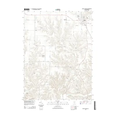
2015 Map of Mount Sterling
USGS Topo · Published 2015About this map
Mount Sterling serves as the primary hub in this portion of Brown County, where the street grid includes corridors like E Union St and E Franklin St near the local aviation hub at Mount Sterling Municipal Airport. Outside the town center, the landscape is defined by the drainage of Dry Fork and McKee Creek, creating a series of hollows including Cronin Hollow and Sarrah Hollow. The area is notably dense with small family and community burial grounds, preserving the locations of early rural life. Genealogists can find the positions of Cleaves Cem, Fargo Cem, and Keifer Cem across the countryside. Small settlements such as Fargo and Buckhorn are connected by a network of rural routes, including Buckhorn Rd and 700N Ave, which reveal the agricultural layout of the region during the mid-2010s.
Find a feature on this map
64 named features on this map. Tap any name to fly to it.
Don’t see what you’re looking for? This feature index may not catch every label — zoom into the map to look around manually.
Map Details
Editions of this 2015 Mount Sterling Map
This is the sole edition of this map. No revisions or reprints were ever made.
Other maps of this area

1923 · Rushville
USGS Topo · 1:62,500

1926 · Rushville
USGS Topo · 1:62,500

1926 · Mt Sterling
USGS Topo · 1:62,500

1928 · Meredosia
USGS Topo · 1:62,500

1929 · Mt Sterling
USGS Topo · 1:62,500

1931 · Meredosia
USGS Topo · 1:62,500

1946 · Augusta
USGS Topo · 1:62,500

1948 · Quincy
USGS Topo · 1:250,000

1949 · Augusta
USGS Topo · 1:62,500

1956 · Quincy
USGS Topo · 1:250,000