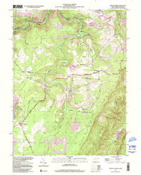
1997 Map of Mount Storm
USGS Topo · Published 2001About this map
Abram Creek carves through the high ridges of the Allegheny Plateau, defining the rugged geography of this West Virginia-Maryland border region. The landscape is marked by a complex history of resource extraction, with numerous strip mines dotting the terrain between Emoryville and Hartmansville. These industrial features sit alongside signs of deep-rooted community life, including the White Hall Sch and several small rural congregations such as Rehoboth Ch and Blake Chapel.
Find a feature on this map
42 named features on this map. Tap any name to fly to it.
Don’t see what you’re looking for? This feature index may not catch every label — zoom into the map to look around manually.
Map Details
Editions of this 1997 Mount Storm Map
This is the sole edition of this map. No revisions or reprints were ever made.
Other maps of this area

1895 · Piedmont
USGS Topo · 1:125,000

1899 · Oakland
USGS Topo · 1:62,500

1900 · Oakland
USGS Topo · 1:62,500

1916 · Davis
USGS Topo · 1:48,000

1918 · Davis
USGS Topo · 1:62,500

1919 · Elk Garden
USGS Topo · 1:48,000

1919 · Davis
USGS Topo · 1:62,500

1920 · Elk Garden
USGS Topo · 1:48,000

1920 · Davis
USGS Topo · 1:48,000

1921 · Greenland Gap
USGS Topo · 1:62,500